Land Consumption Analysis
The Analyst Land Consumption module quantifies the land converted for development in future land use scenarios. Comparative scenario results demonstrate the impacts of different growth patterns, which may take place as infill/redevelopment or greenfield development. Converted land area is classified according to its existing condition, yielding five categories—agricultural, woodland, other greenfield, urban vacant, or urban redevelopment.
Analysis is run at the scale of the project canvas, generally parcels, yielding a spatial output layer and corresponding data table; both can be used within Analyst for mapping and data exploration, and exported. The module also reports individual and comparative scenario results via summary charts, and generates a spreadsheet summary in Excel format.
Methodology
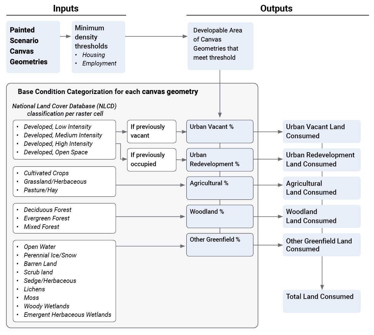
The Analyst Base Canvas and painted scenarios represent development via Building and Place Types. For future scenarios, analysis assumes that the application of building and place types to the Canvas Geometries leads to the consumption of all the “developable” area within each, provided that the incremental density of new growth meets a minimum specified threshold. The analysis process is summarized in Land Consumption Analysis Flow, and described in the following sections.
 |
Calculations
The module first calculates the painted housing and employment densities for each painted parcel to assess its development status. Painted density is measured as the increase in dwelling units or employment in the scenario being analyzed as compared to the Base Canvas, divided by the developable area in the parcel.
The module then filters the canvas for parcels that have painted densities greater than the minimum specified density thresholds, which are defined by users as input parameters. The total developable area within each parcel meeting the minimum condition is considered as land consumed.
Lastly, the module classifies the land consumed into the five land cover categories: agricultural, woodland, other greenfield, urban vacant, or urban redevelopment. The total area of each “consumed” parcel is multiplied by its proportional share within each of the five categories, yielding land consumed by each category.
Base Condition Categorization
The categories of the base condition are derived from the National Land Cover Dataset (NLCD) 2011 for all of the United States but Hawaii. For Hawaii, the National Oceanic and Atmospheric Administration (NOAA) Coastal Change Analysis Program (C-CAP) Land Cover 2011 dataset is used. Both are derived from satellite imagery and assign values to 30m by 30m pixels.
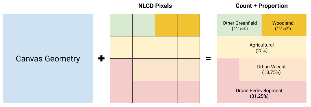
Using a raster-based calculation, the module counts the number of pixels in each parcel/ block by NLCD classification. For the “developed” NLCD classifications, the pixels are counted towards the “Urban Vacant” category if the parcel/block is vacant and “Urban Redevelopment” if the parcel/block had any dwelling units or jobs on it. Using these counts, we get the proportional share that each of the five categories contribute to that parcel/block. This process is illustrated in Base Condition Categorization.
 |
Input Parameters
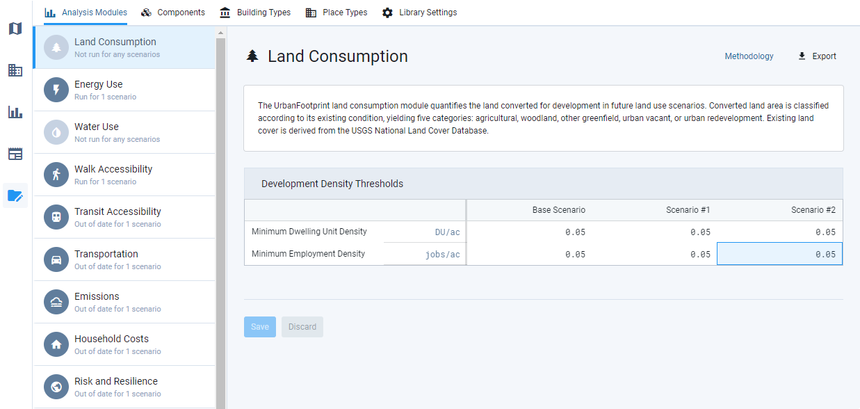
The housing and employment densities of new development on a parcel or block must meet a minimum threshold in order for the developable land area of a parcel or block to be considered as consumed. By default, these cutoffs for increases in dwelling unit (DU) and jobs density are 0.05 DU/acre or 0.05 jobs/acre, respectively. Parcels/blocks with painted development at densities that fall beneath these thresholds are not included as consumed land. This allows users to introduce “conservation” land uses in future scenarios without the changes being considered as urban development.
The minimum development density thresholds can be set individually for each scenario via the Analysis Module Parameters Manager, as shown in Land Consumption Module Parameters Manager.
 |
Output Metrics
The Land Consumption module generates a spatial output layer and corresponding data table; both can be used within Analyst for mapping and data exploration, and exported. The module also reports individual and comparative scenario results via summary charts, and generates a spreadsheet summary in Excel format. The attributes of the spatial output/data table are summarized in Land Consumption Module Outputs.
Attribute(s) | Description |
|---|---|
Urban Vacant Land Consumed | The amount of urban land developed in the scenario that was previously unused, meaning that it had no dwelling units or commercial use. Urban land is identified as NLCD "developed" land use categories. |
Urban Redevelopment Land Consumed | The amount of urban land developed in the scenario that was previously used, meaning that it had either dwelling units or commercial use. Urban land is identified as NLCD "developed" land use categories. |
Total Urban Land Consumed | The total amount of urban land developed in the scenario. Urban land is identified as NLCD "developed" land use categories. |
Agricultural Land Consumed | The amount of land developed in the scenario that was previously used for agriculture. Agricultural land is identified as the following NLCD land use categories: Pasture/Hay, Cultivated Crops, and Grassland/Herbaceous. |
Woodland Land Consumed | The amount of land developed in the scenario that was previously woodlands. Woodlands are identified as the following NLCD land use categories: Deciduous Forest, Mixed Forest, and Evergreen Forest. |
Other Greenfield Land Consumed | The amount of land developed in the scenario that was previously greenfield areas not classified as agriculture or woodlands. Greenfield is identified as the following NLCD land use categories: Barren Land, Dwarf Scrub, Shrub/Scrub, Sedge/Herbaceous, Lichens, Moss, Woody Wetlands, or Emergent Herbaceous Wetlands. |
Total Greenfield Consumed | The total amount of agricultural, woodland, and other greenfield lands developed in the scenario. |
Percent Vacant Land Consumed | The percentage of all consumed land in the scenario that was previously unused, meaning that it had no dwelling units or commercial use. Urban land is identified as NLCD "developed" land use categories. |
Percent Redevelopment Land Consumed | The percentage of all consumed land in the scenario that was previously used, meaning that it had either dwelling units or commercial use. Urban land is identified as NLCD "developed" land use categories. |
Percent Total Urban Land Consumed | The overall percentage of land consumed in the scenario that was urban. Urban land is identified as NLCD "developed" land use categories. |
Percent Agricultural Consumed | The percentage of all consumed land in the scenario that was previously used for agriculture. Agricultural land is identified as the following NLCD land use categories: Pasture/Hay, Cultivated Crops, and Grassland/Herbaceous. |
Percent Woodland Consumed | The percentage of all consumed land in the scenario that was previously woodlands. Woodlands are identified as the following NLCD land use categories: Deciduous Forest, Mixed Forest, and Evergreen Forest. |
Percent Other Greenfield Land Consumed | The percentage of all consumed land in the scenario that was previously greenfield areas not classified as agriculture or woodlands. Greenfield is identified as the following NLCD land use categories: Barren Land, Dwarf Scrub, Shrub/Scrub, Sedge/Herbaceous, Lichens, Moss, Woody Wetlands, or Emergent Herbaceous Wetlands. |
Percent Total Greenfield Land Consumed | The overall percentage of land consumed in the scenario that was either agricultural, woodland, or other greenfield lands. |
Total Land Consumed | Total developable land area in areas that satisfy the minimum density thresholds for dwelling units and employment. |
Land Consumed by Type | Greenfield, Agricultural, Woodland, Vacant and Redevelopment land consumed in acres. |