Parcel Reference Data Exports
The Parcel Reference Data layer is available via the Layer Manager for all projects with a parcel Base Canvas. The layer includes parcel information from the source data provider, including APN numbers; addresses; land use and zoning codes; and assessors' data on property values, taxes, and building characteristics. Data from the layer can be exported for most places in the United States; in old projects for a small number of counties, exports are disabled in older projects due to restrictions on the source data.
For all other areas, exports are allowed. However, to comply with our third-party agreement with the source data provider, they cannot be exported as a full geospatial dataset. Instead, the Parcel Reference Layer data can be exported in two parts: 1) a shapefile containing the parcel geometries; and 2) a CSV file containing the parcel attribute data. Using a GIS program, you can then join the CSV data to the parcel geometries. You can also export the parcel reference data as a standalone CSV file for spatial analysis.
Note
Analyst does not manipulate the data from this layer, and its details reflect the information provided by the source data provider. Therefore, some columns, such as Improvement Value, Land Value, or Improvement to Land Value Ratio, may not be available for all places.
Export Parcel Reference Data
From the Layer Manager, add the Parcel Reference Data layer to your project. The layer is available in the Land Use category for projects with parcel-scale Base Canvas.
Note
Like the Base Canvas, the Parcel Reference Data layer dates to the time of project creation, and remains static within a project. Quarterly updates to the Analyst Base Canvas do not affect existing projects. To access the most recent parcel data for an area, you must create a new project.
Click on the Parcel Reference Data layer in the Layers list.
From the Layer Details pane, click the Download layer button
 and select the desired format from the list. The options include:
 CSV w/o geometries – A tabular data format suitable for use in spreadsheet or database applications. The CSV export contains the parcel reference data attributes. You can also export parcel reference data to CSV format from the data table; see Use the Data Table.
Shapefile - A geospatial vector data format for use in GIS programs. The layer is downloaded as a zip file containing the shapefile (.shp) and supporting files for the parcel geometries, along with a CSV file containing the parcel reference data attributes.
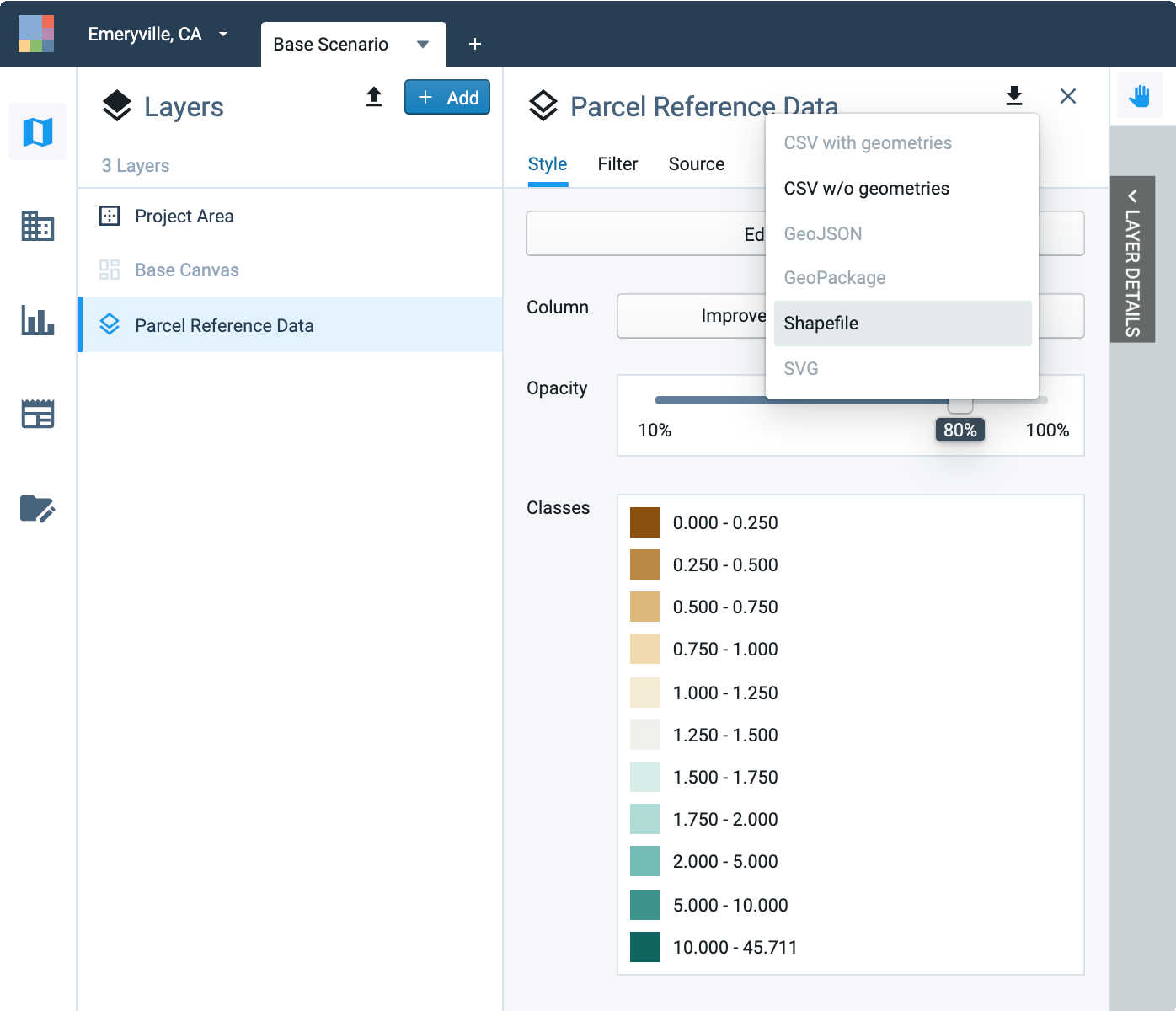
Export options for the Parcel Reference Data layer
Note
If the CSV and Shapefile download options are disabled, the parcel reference data is subject to export restrictions per the source data provider. See Layer Export Restrictions for more information.
Your export will include all features in the layer, even if a filter selection is active. To export data for a filtered selection, you must first save your selection as a new filtered layer. You can also export CSV data for a manual or filtered selection of parcels using the Export to CSV control in the data table.
Once you select a data format, Analyst will prepare the download, and a pop-up window will appear at the bottom of your screen when the layer is ready.
Click DOWNLOAD in the pop-up notification to download the data. The layer will be downloaded to your computer. Depending on their size, layer exports may take some time to download. You can find the downloaded file in your default downloads folder.
Join Parcel Data Attributes to Parcel Geometries
Shapefile exports of the Parcel Reference Data layer consist of a zip file containing: 1) a shapefile containing the parcel geometries; and 2) a CSV file containing the parcel attribute data. You can join the CSV file to the shapefile to produce a full geospatial layer using a GIS program.
The shapefile contains a geometry key column (truncated to geometry_k) that corresponds to the geometry_key column in the CSV data table. The geometry key columns should be used as the basis for an attribute join (join by attribute) between the two files. For further help, please refer to the resources for your GIS program.