Reference Data FAQs
Frequently asked questions about reference data available in Analyst.
- How can I find out when a dataset was last updated?
- There's an updated version of data available for a reference data layer. When will it be loaded to Analyst?
- Can I export the Parcel Reference Data layer?
- Can I get a list of the reference data layers available for my project area?
- Can I limit the spatial extent of reference data layers?
- Can I rename layers?
How can I find out when a dataset was last updated? | |
The metadata for each reference layer indicates when it was last updated by the source. Metadata can be viewed via the Layer Manager, or the Source tab in the Layer Details pane. See Use Reference Data for further information. | |
There's an updated version of data available for a reference data layer. When will it be loaded to Analyst? | |
Analyst routinely updates the reference data library. For information about the status of a specific reference data layer, please contact Analyst support. | |
Can I export the Parcel Reference Data layer? | |
Parcel reference data (available via the Layer Manager for projects with a parcel-scale Base Canvas) can be exported for most places in the United States. For guidance, see Export Parcel Reference Data. Note that exports are disabled for a small number of counties due to restrictions on the source data. If you'd like to verify whether your project area is affected, please contact Analyst support. | |
Can I get a list of the reference data layers available for my project area? | |
Yes, we can provide this information. Please contact Analyst support for assistance. | |
Can I limit the spatial extent of reference data layers? | |
Reference data layers are loaded to projects to include features that intersect a rectangular “bounding box” delineated as one degree latitude and longitude beyond the outer limits of a project area. Including these data is useful for providing information about your project context. You may want to limit the extent of reference layers, however, for more focused data analysis and mapping. To do so, create a filtered selection of reference data layer features within a project area by applying a join filter, using the Project Area layer as the join layer. Then, save the selection as a new filtered layer. See Filter and Join Data for steps on using join filters and saving filtered layers. | |
Can I rename layers? | |
Yes, you can rename most layers, including reference data layers, saved filtered layers, or layers that you upload yourself. Exceptions include the Base Canvas, Scenario Canvas, and any output layers generated by the analysis modules. To change the name of a layer, roll over a layer entry in the Layers list and click the Open menu button 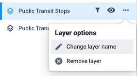 Find the Change layer name control on the Layer options menu. |
