Wildfire
Wildfire is an unplanned and unwanted fire burning in a natural area. Wildfires can spread to developed lands and pose a severe risk to life and property. UrbanFootprint ingests publicly available wildfire risk datasets and intersects them with the threatened people and property.
The U.S. has seen a billion-dollar wildfire disaster in each of the last eight years. Wildfires such as Lahaina, Marshall, and Paradise have wiped out entire communities and caused unprecedented losses of life and property. Disasters like these may become more common due to factors such as global warming and the expansion of development into the wildland-urban interface.
UrbanFootprint Wildfire provides the annual probability of wildfire in current and future scenarios.
Example Maps in Analyst
This pair of images showcases how you can visualize wildfire in Analyst. In these examples, there is an increased annual probability of wildfire, with more areas exposed to wildfire in the future scenario.
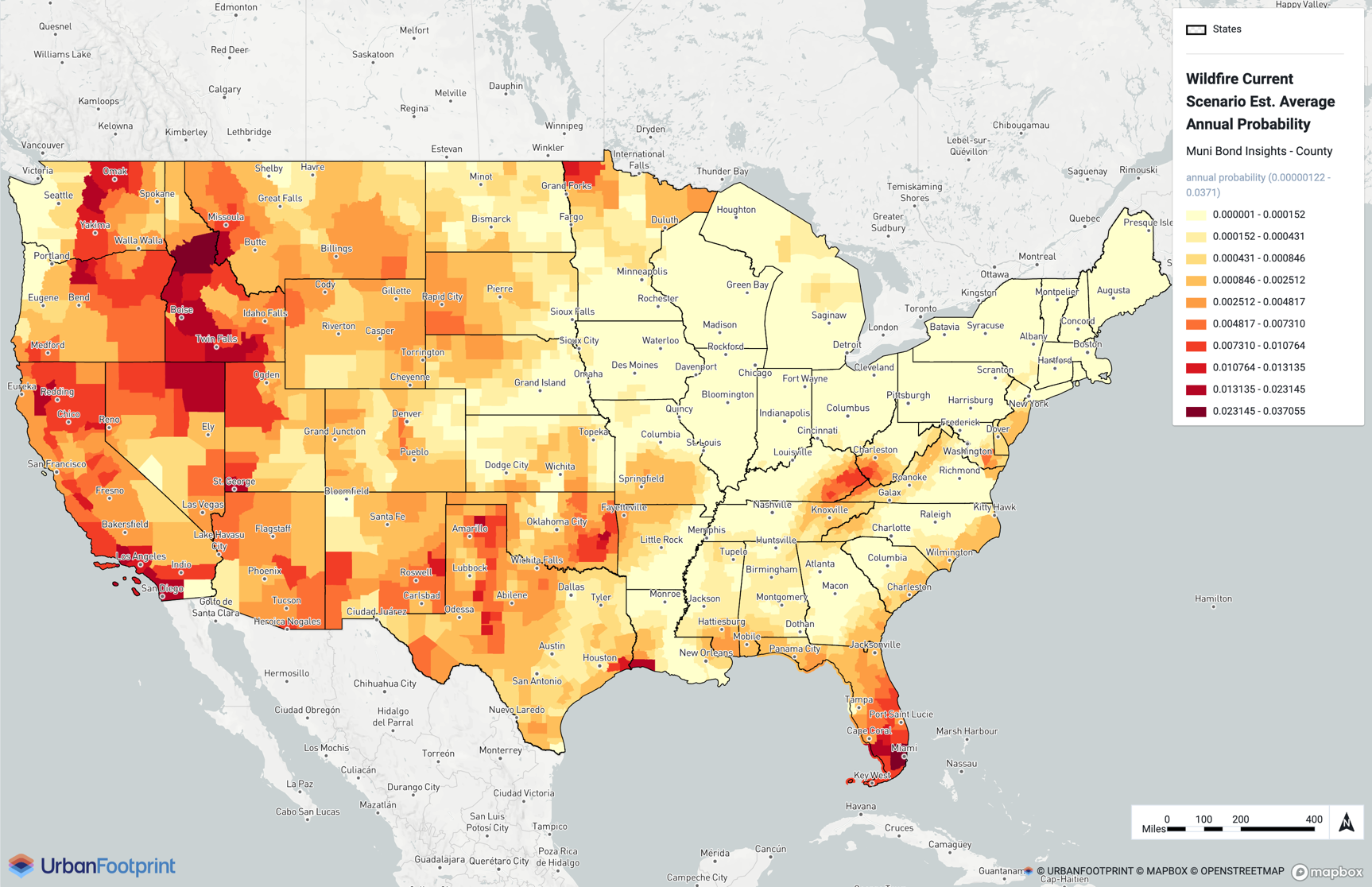
Current scenario
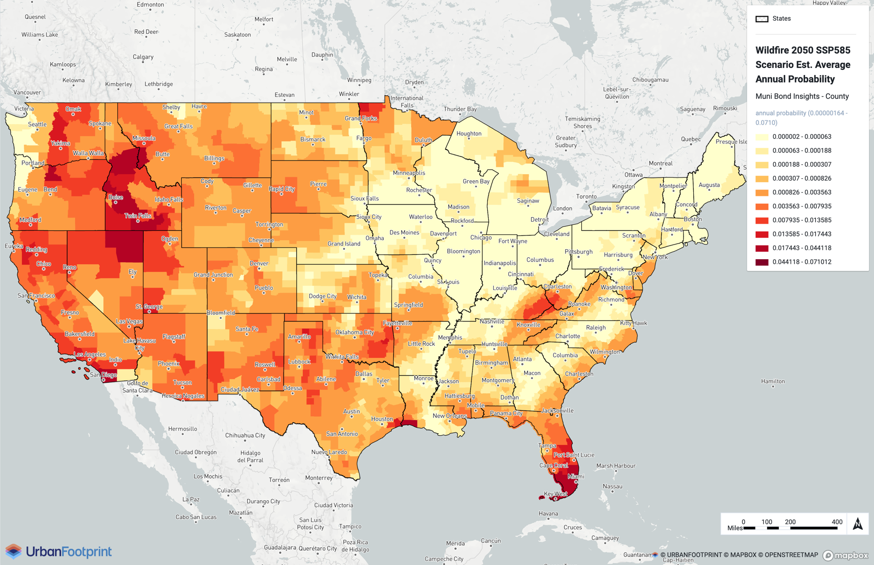
SSP5-8.5 2050 scenario
Details
UrbanFootprint addresses organizations' need to capture the risk of wildfire by geospatially intersecting the best available models of wildfire risk (Wildfire Risk to Communities datasets) with the people and property that are threatened. The models that generate this data consider wildfire risk from fires that ignite in wildlands and then spread to urban areas. The modeled spread of wildfire is limited to 1,530 meters (~1 mile) from the perimeter of urban areas. The model authors note that this limit is consistent with observed structural losses in urban areas due to wildfires over the last 20 years. Therefore, urban areas more than 1 mile from the boundary are not considered to be considered at risk of wildfire.
For current wildfire probability, we use Wildfire Risk to Communities, a high-resolution (30 x 30 m), vetted national fire risk dataset with several layers that give different perspectives. Specifically, we include the:
Burn probability (BP) layer – provides the annual probability of wildfire (at any flame length greater than 0 feet) burning at the location
Flame length exceedance probability layers of 4 feet and 8 feet (FLEP4 and FLEP8) – indicate the conditional probability of flame length exceeding 4 feet and 8 feet if a wildfire occurs. Greater flame lengths indicate the potential for wildfire intensity.
Using the mean burn probability and flame length exceedance probabilities, we calculate the probability of wildfire with flames exceeding 4 feet and 8 feet:
Probability of wildfire with flames exceeding 4 ft = BP (burn probability) x FLEP4 (flame length exceedance probability 4 ft)
Probability of wildfire with flames exceeding 8 ft = BP (burn probability) x FLEP8 (flame length exceedance probability 8 ft)
For future wildfire probability, we follow the emerging scientific consensus (Gao, et al. (2021), Gutierrez, et al. (2021), Riley, et al. (2016) that identifies high temperatures as a strong predictor of future burn probabilities. Specifically, to estimate the future burn probability, we scale the current probabilities based on the forecasted number of days above 95°F as the threshold above which wildfire burn probability increases substantially.